Burdekin Major Integrated Project — Gully Maintenance and Monitoring at EMOHRUO
Working together to achieve the best possible result
The Burdekin Major Integrated Project Gully Maintenance and Monitoring project is drawing upon the knowledge of graziers and technical specialists to guide how best to maintain remediated gullies.
This is an important tenet of NQ Dry Tropics’ extension program — collaboration with key stakeholders, including landholders, to work towards solutions for NRM outcomes. It leads to deeper insights, fresher perspectives and delivers results.
This video shows collaboration in process. It features Scottville grazier Stan Fordham and NQ Dry Tropics Soil Conservation Officer Bernie Claussen discussing the challenges of working with sodic soil and the need for properly considered and planned maintenance.
They consider potential solutions to maintain the site while ensuring effectiveness of remediation efforts.
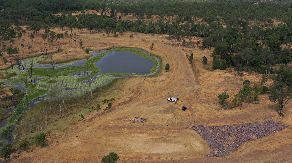
The site
(Completed 2020)
Erosion repair works were undertaken at one of the property’s major water sources, Miners Dam.
This involved widening the dam’s by-wash with reshaped batters and constructing a rock chute to reduce the speed of the water leaving the dam. Soil removed for these works was used to level the south east dam wall.
Rock chutes were installed to prevent existing eroding gullies progressing up the by-wash. This included using a geofabric liner.
An erosion control bank was constructed and contour ripping completed upslope adjacent to the dam to manage surface water flow to promote paddock pasture establishment.
Monitoring
The site is being monitored to evaluate effectiveness of treatment.
It’s monitored each year in the post wet season (April-July).
Site monitoring applies industry standard tools Land Condition Assessment Tool advanced (LCAT) and Gully Maintenance Tool (GMT). These tools enable finer scale changes to be measured over time.
1. Land Condition Assessment Tool advanced (LCAT)
A minimum of two LCATS are carried out immediately upslope of the gully, in the base of the rehabilitated gully, and opportunistically depending on local conditions.
LCATs indicate many biophysical aspects demonstrating the process of gully stabilisation.
2. Gully Maintenance Tool (GMT)
GMT surveys take into account a range of biophysical elements including gully head movement, treatment type, treatment stability, ground cover and composition, species, rainfall, and photopoints targeting key gully and erosion features.
Landholder feedback about stocking data and environmental influences such as rainfall is also collected.

Gabion baskets being installed during earthworks at Emohruo.
Landholder observations
Rehabilitation benefits
- Active erosion has stabilised, reducing sediment into the creek.
- The establishment of native grasses on the site has increased grazing value.
- Ripping upslope adjacent to the earthworks helped break up compacted and poorly structured soils to generate structure and porosity. This helped promote vegetation growth.
Lessons learned
- Keep dispersive soils buried under topsoil (and organic matter) because “if you don’t, the first shower of rain will create rills and cracks that will cause a massive erosion problem down the track if not fixed quickly”.
- Ensure runoff from hard areas is not discharged into areas with exposed dispersive soils. “Running water will find any cracks in the ground and cut new channels into erodible soil.”
- Need to create areas for discharge of runoff, whether that’s through channels, weirs or banks designed to help slow water down and disperse it across the landscape.
- Maintaining vegetation cover is key to keeping soil in place and reducing runoff.
- Before doing any earthworks, it’s important to consult an experienced, qualified civil engineer or soils specialist to discuss options.
Stan’s assessment:
The earthworks are great, the integrity of the dam has been safeguarded, and I believe in the long-term the widened by-wash and rock chute will stop a lot of sediment from running into the creek.
What’s really good is the by-wash has been doubled in width to be able to handle a lot of water, including velocity. We haven’t had a wet season to produce a big flow so the works haven’t been tested properly yet. I’m pretty confident it’ll work.
I’m really pleased with the pasture growth. It’s come back well. The ripping upslope, to break up compacted soil, has improved water infiltration. It’s September and getting dry and the pasture is holding up well.
A bit of erosion has occurred on the north facing slope including mainly rilling where the slope is steeper. These may need to be reshaped to a lower gradient.
Water is coming from a small catchment upslope, contributing to the rilling. Perhaps a bund wall or some other type of bank structure needs to be constructed to slow the water down, and spread it out.
I moved rock into a breakaway that started forming, but it’s not working as well as it could, mainly because when water runs downslope and finds a crack, it’s pretty much a lost cause. When subsoil gets exposed to water and rain it gets soft and just falls to pieces.
You do some earthworks and when it’s finished it looks lovely and you think it’s going to be right forever, then it rains. There’s going to be ongoing maintenance.
Grazing land management
- Stock was excluded for 12 months following earthworks to help stabilise the site and to encourage vegetation growth.
- Stock numbers have been managed in the past three years to encourage and maintain vegetation cover.
- This year (2023), stock grazed the paddock for three months, and will be removed for wet season spelling.

Work underway to widen the bywash.